
Reported by Rob Roggema
Between 3 – 8 November 2019 the M-NEX team held its bi-annual workshop in Sydney. The Sydney theme within the project is to investigate design-led solutions for the regional scale in an intensive development area constrained by multiple climate impacts of which extreme heat in the Australian summer is the most significant.
Western Sydney Parklands, case study
The M-NEX case study area in Sydney Metropolitan area is the so-called Third City of the Western Parklands. Here, a new ‘Badgerys Creek’ Airport will be constructed, and this gives reason to project a large agri-business complex, 100-thousend of jobs and new residents in the area. This all needs to happen in a landscape that is dominated by a fine system of gullies, creeks and waterways, tied together in a hilly landscape of the Cumberland plain. This gave the M-NEX team reason to start the design with the systems that formed the landscape in the first place: water, ecology, soil.
The design charrette process
The process during the workshop was led by consideration how to facilitate spatial design in the best possible way, whilst engaging local stakeholders in a creative way.
The M-NEX team therefore started with a mini design workshop in which local and regional knowledge was used to conceptualize the first spatial propositions how to create a cooling landscape for the new urban precincts. These propositions were then presented to the local stakeholder group that participated in the design charrette and functioned as inspiration for the design process that followed. In a two-day charrette the M-NEX team worked with local stakeholders in a creative and stimulating way to find spatial solutions to localize FEW-systems, and meanwhile developing a cooling strategy for the city. In four groups the participants started brainstorming possible ideas on four themes: food, energy, water and cooling. The generated ideas were then collectively rated in three categories: easy to realize (blue), challenging to realize (red) and dreams (yellow). The top-ranked red ideas were then taken back into the groups to be enriched by the best supporting ideas from the other two categories. Together these were then transformed into design projects, which were designed at regional and local scale. After the final design exercises, the groups worked on building a model of the two most relevant integral proposal at a local site, using plasticine. The design charrette ended with presenting the work in a comprehensive and concise way. The way this process was organized stimulated creativity, out-of-the-box thinking and collaboration between stakeholders and professional experts of the M-NEX team. New insights emerged in the form of concrete spatial proposals that can be applied and used in the current urban development process for the Western Sydney Parklands.
Spatial solutions for the FEW-Nexus at regional scale
As result of the design charrette several spatial strategies and solutions came to the fore.
Firstly, a food-forest strategy for supporting building of homes, increasing biodiversity and growing food was designed (figure 1). In this concept the spatial strategy consists of planting eight million trees in the Western Sydney Parklands, one for every Sydney Metro resident in 2045. By planting these trees from now onwards they can start growing already and provide a cooling canape for later urban infill. Also, using some forest areas to generate building materials for the construction of homes with the timber that grew in these areas. Trees capture carbon and nitrogen and hence can compensate for the emissions and health problems caused by regular building and infrastructure projects.
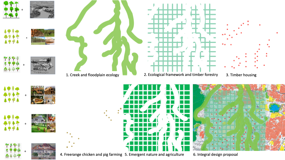
Figure 1. Step-by-step design realizing intense urban development based on food-forest strategy
The integrated spatial proposition consists of five main indigenous forest typologies, which can be realized in sequence.
- Broadening of the creek banks. This would enhance the capacity for dealing with flooding in and around the creeks in the area, while it also increases biodiversity. At the same time the zones around the creeks provide a cooling landscape and water is able to infiltrate in the soil, which keeps the soils healthier and fertile. It finally provides the capacity to store surpluses of water for a prolonged period and purified household water can be used to keep water in the waterways in all seasons, which especially in summer contributes to cooling the city.
- A second intervention is the introduction of a so-called ecological support frame. This grid of wood emphasizes the required connections between the creek zones and provides the gradients between the higher, nutrient poor and drier grounds and the nutrient richer soils of the lower grounds. Hence ecological exchange and capacity is supported.
- Within this supportive ecological grid, compounds with timber suitable for construction are deployed. This timber, grown in one km2 areas, provides the wood for building homes in high densities. These urban quadrants could host approximately 20,000 people. A total of 50 of these quadrants are planned on the higher elevated areas in the region and are sufficient to offer housing for an estimate of one million people.
- The forest areas located under the flightpath of the new airport are used in similar sized compound for free-range chicken and pig farming. The animals can, within limits forage freely under and in between the trees and provide a high-quality product from local land.
- The land that remains after these spatial interventions is redundant space, which may emerge as it comes. This way food can be grown and an ecological basis quality can develop over time.
Secondly, the zone under the flight path is generally a useless space in which most land-use is prohibited. The M-NEX design team proposes to think diametrically about this and turn the nuisance zone into a productive and supporting cooling and heating processing zone (figure 2).
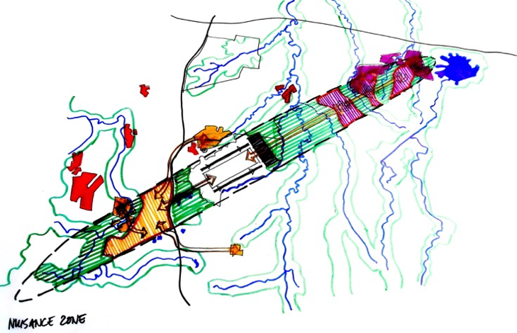
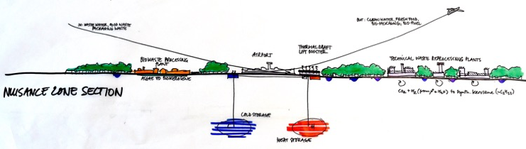
Figure 2. Turn the nuisance zone into a resource generating landscape, meanwhile helping aircrafts take off and land
In this zone the waste that an airport undoubtedly brings forward will be processed and turned into resources. At the same time a huge heat pump could store heat in summer hence cool the environment and release it in winter. Finally, playing around with the intense heat and the absorption or reflection from roof would make it possible to take-off and land with less effort, e.g. energy usage.
The third spatial solution is found in division of urban landscapes in order to intensify urbanity and leave large green spaces separating the conurbation. These green fingers, similar to the Copenhagen urban region design, make it possible fresh air from the Blue Mountains in the west ventilates deeply into the urban fabric of the new Parkland City. It also provides the spaces to grow urban food in high-tech systems within the built structures in the urban precincts and create low-tech agricultural landscapes locally. This makes it possible to connect and integrate local circular flows of food, energy and water systems.
Fourth, a range of design ideas were developed for small scale build systems that integrate food energy and water at the building and street level. These solutions close loops at the lowest possible scale.
Learnings & findings
- On the basis of maps and local experts, the M-NEX team advised to start with designing the conceptual spatial vision, then define knowledge gaps and ask for specific data and research, on the basis of which the design vision is adjusted, elaborated and detailed. This process is iterative and can be repeated several times in order to produce detailed and evidence-based design proposals for the site. Design is magical as it can create a whole new reality out of nothing.
- This design-led process can be applied at every scale, from the regional landscape scale to the built urban form and built structures.
- A long-term strategy should be developed for the Western Sydney Parklands in which indigenous knowledge and indigenous species are used to shape the far future now. A food-forest strategy could help to create a cooling landscape and provide local productivity and biodiversity.
- Sydney should be extremely considerate of unconscious and ever-expanding sprawl. This is path-dependent and in the minds of the local stakeholders the ‘normal’ way of delivering new parts of the city. However, uncontrolled sprawl, and even if it is even controlled, has many negative impacts on resource depletion, the sustainability of local food, energy and water systems, as well as mobility and well-being of the residents, and only exaggerates climate to change and impact on the very same area.
- Turn the airport into a productive and sustainable element which contributes to the resource provision and -generation in the regional landscape, provides the residents with a qualitative environment, and mitigates the waste, exhaust as well as the noise and risks of the airport. An ordinary airport which is only operating to let planes land and take-off, no matter how well-designed the terminal might be, does not contribute to the quality of the environment, does not generate the number of jobs expected, and only increases global and local problems.
- Given the expected new residents in the Sydney region, a new city should not be designed to accommodate the desires of traditional Ozzies. Instead, new influx of, mainly, Asian people pose a new urban design question of higher densities, smaller homes, alternative cultural urban agriculture and tech-driven convenience to the area. The biggest mistake is probably to design the city for the old people not the new.
- Work from the large, regional, scale towards the lower scale. Start with the landscape systems, such as elevation, topography, water, soil and ecology, which guide local scale designs that then need to fit within large-scale objectives and propositions. Parallel to this, work from the bottom up using local expertise and design a built form and structures that not only fit in the larger scale, but also shape and feedback into this larger scale, which the on its turn adjusts itself to the needs of the local design proposals.
- Creativity and engagement of local stakeholders works best if the process is well-structured, tightly planned and includes short turnarounds and clear deadlines, as well as the need to present findings in a concise and clear way during the process and at the end.
- To design the landscape first, use indigenous planting, prevent suburbian sprawl, and turn the nuisance of a flight path into a productive site and use the connected food-energy-water nexus as the local driver for increasing the resilience of a regional landscape under pressure of climatic impacts is an example the other partner cities, and other city-regions beyond these, can use and apply in their own contexts.
- The design-oriented process using a creative step-by-step way of working towards integrated design projects at local and regional scales can also be used in the other M-NEX partner cities and other SUGI-projects.
The M-NEX workshop in Sydney was a great success, mainly because of the concrete spatial propositions the team could develop together with local participants. The next steps will be to report on the solutions and findings and present these to the Greater Sydney Commission, the Western Sydney Airport Authority, State Government, the local councils and local stakeholders alike.